 Live Music Archive
 Librivox Free Audio
 Metropolitan Museum
 Cleveland Museum of Art
 Internet Arcade
 Console Living Room
 Books to Borrow
 Open Library
 TV News
 Understanding 9/11
tv [untitled] November 16, 2013 2:30pm-3:01pm PST
2:30 pm
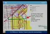
freeway just keep going down mission street to mission bay. that will reduce not only the travel time of the existing service but will create a new travel market to see how well this is performing in the period. our goal is to have this opened around the spring of 2016 so it's opened with the hospital and we'll work this out through our next fiscal budget. if we can hire the operators. this is an opportunity to tie into the development going on in the area and tie that connection. and once we figure out the transportation issues, this would be the preferred
2:31 pm
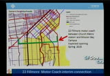
trolleybus route. second what we are doing now is there has been several concerns about the performance and the eastern neighborhood area. we've been working an looking at the specific signal issues along the corridor. some of the signals weren't completed or weren't upgraded as we had hoped were upgraded. we identified some areas. >> when will that be complete? >> hopefully by the end of this year we'll have all of those complete. so early neck year you should start to notice significant difference in the areas where the t gets stuck in bottle neck where it makes the right and left turn and down towards mission bay and we
2:32 pm
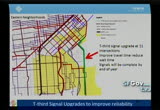
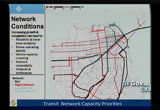
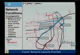
should start to see that signal working more effectively and we should start to see more customer experience. obviously that is not enough, we know there is specific network capacity issues we need to work on and the area around 4th and king is going to be an on going issue so we can get to relive -- relieve that bottle neck. this is the capacity issues on the rail networks. the whole system works as one in a lot of areas we have crowding and over crowding and people miss their train because they can't get on. the peak period is growing. this is an on going consumer problem we have. what are the short-term things we can do in the next couple of years to relieve the
2:33 pm
load. there are a couple examples to alleviate that. with that we can look at how we can improve some of the portal access points that creates a lot of this bottle neck and whether there are some specific changes we can do outside of the system as well as the inside of the system. as you know we introduced a 3-car service at the end to help relieve the congestion for crowding and coming up with some additional lines to address that as well. as part of the traffic improvement, here are the lines that come through. what you are looking at is a study is to identify how we can help quickly. in addition to that, overlapping corridor that i showed you that
2:34 pm
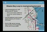
had the signal improvement is the reason why we are looking at this mission bay loop. the mission bay loop is really to really accommodate the additional service of the central subway in 2019. what the loop will do is provide additional train access and further improve the frequency through the bulk of this area from the plan to every 5 minutes. you have a basically a show and go service through this corridor. south of mission bay the service will improve from 9 to 7 1/2 minutes by 2019. our goal is to improve to every 5 minutes. i know there is a concern about the mission bay loop and this is what we are doing to get ourselves ready to come district attorney it the increase in demand in this corridor. so long-term we
2:35 pm
know there is a lot of things we need to do. there is a long term transit vision so we can start to work on the times of these red corridors. these are the highest capacity corridors that we have in the system and these run through middle of the city and the cal train car which is going to be electrified and increase rider ship and access. we are looking at these five corridors to try and strengthen their capacity and improve their time. we have this benchmark goal to figure out the projects to have consistent travel times in each parts of the city we should start to see this major shift in growth in more transit service and transit use. >> i have a question. thoos -- this is long-term, a vision. >> i can appreciate that vision
2:36 pm
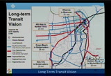
to get from one side of the city to the other side of the st e in 25 minutes. is it through technology? >> it's a combination of things, basically dedicated right of way so really pushing forward on dedicated right of way. it's segregated right of way which maybe a great separation. so there is no interference with vehicular traffic. it will also include consolidation and potentially expressed service. so these are kinds of things we are looking at. the great separation are the high capital cost very long-term opportunities and the technology skip stop different stages of the signal systems, more of the short-term, medium term opportunities. this road capacity study will look at this and explain it in detail because we know with some of these things is 25-30 years away but there is things we can
2:37 pm
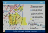
do in the next two to 3 years that we can improve that. there is areas taking space from travel lanes or parking, we are going to need your help to prioritize so we can move these projects forward. >> you also probably need the future board's help. >> it's going to be very ong on going. i think the tup will need the boards help. yes, all future board's help also needed. moving on from transit to walking priorities. as part of the pedestrian task force, mta currently led the department of public health and worked with
2:38 pm

planning and dpw and many other agencies as well on developing the walking corridors where people are consistently being injured by car collisions. and these intersections are the area where the specific hot spots are seeing consistent issues with traffic collisions. what we've done is basically, we are in the process right now of prioritizing these corridors and developing a work product around them. and just for your reference, supervisors, 8.8 miles of 70 miles are in the eastern neighborhoods plan area. four of the high intersection hot spots are in the eastern neighborhoods plan area. so we are looking at the measures that help us reduce the propensity for risk and injury exposure and we'll get that out. our goal is to have
2:39 pm
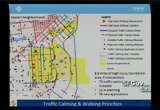
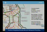
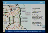
that priorization report ready for next spring and working to develop the funding for that which works with the plan. we highlighted about 73 measures installed in this area already. 12 are currently in planning and being designed right now and we have 56 new applications. the up and coming measures are strong and robust. the team has developed a new stream lining process which will get those prioritized and delivered as quickly as possible. bicycling in the area we have seen a tremendous growth in bicycling in the core bicycle area which is about half of the eastern neighborhood area plan has seen most of the dramatic
2:40 pm
growth in bicycling. since the 2000-2010 census, many areas in the mission and the south soma area have seen more than a hundred percent increase in cycling in the periods. there is a lot of people bicycling through this area. the mission in particular has the highest for bicycles by folsom and market street. we've also looked at the changing land use patterns in the area and the area has increased area for bicycling ride. the road is flat and there is key areas that need significant
2:41 pm
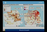
improvement, button general the great network and the topography is very favorable. it's just the condition is such that we are going to need to do a lot more contiguous and connected bicycle infrastructure. what we've development now with the bicycle strategy is a new form of assessment of our existing bicycle network which is what we call level of traffic stride. it's a feel for a general population about how they feel riding their bicycles through different corridor. the level of traffic stress 1-46789 think of the jfk drive or riding through golden gate park. that's where people feel assessment level four, no one feels safe and 2 and 3 are
2:42 pm
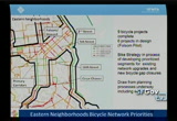
various indications in between. we can see where the areas are that need a lot of work and where are the gaps in the area that need to be closed an where are the systems that need to be up grated. it maybe a bicycle lane and maybe a signal. this is all we are looking at to get us to improve bicycle safety. some areas that are currently under way. the folsom piety is -- pilot is going to be opened up this year. >> where are these projects. >> i have got them underlined.
2:43 pm
>> really quick, how did you come to determine that these were your priorities? >> these from the bike plan from the 2006 bicycle plan and we are at the tail end of the bicycle plan and we are releasing all the projects and now we are going to a dramatic set of projects now. >> the projects that are in design you have a lot of stuff at least two, 16 street and caesar chavez connecting from east to west but nothing from north to south. i have heard a lot of complaints and challenges around illinois that are part of 3rd street. >> that is part of the design upgrade. as far as these projects now, we are developing two categories of improvements and we'll be working with many stake holders to develop that. one is to close the gaps in the
2:44 pm
existing network and the second category is to create to identify the gap closures that doesn't exist now. even to identify these, where the gap is going to be closed an some of the east and west connection in the eastern neighborhoods in the water front area. that will be part of that process. almost the be process in engaging in that and looking for your community participation in that. >> just to wrap up. a lot of what's been going on because there is a lot of work we need to do and we are in full steam with it. the key and next steps now is to implement the current transit bus and initiatives and get them delivered and starting to analyze their effectiveness and because determine the efficacy and we develop the technology. and second is to
2:45 pm
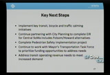
continue to working with the planning department so they can complete the eir. our goal is to have these completed by 2015. our goal for the priorization is for next spring to look at the funding opportunities with that and as of mentioned before, all of this is mentioned at being working very closely with the mayor's transportation task force. mta is one of the service supporters and we strongly believe there is a great opportunity here to look at not only stepping up locally but the help from the regional state and federal partners and also our private partners through development agreement, there is an at some point for all four areas to close a lot
2:46 pm
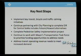
of these gaps. and the last area which are specific challenges with our partners to improve the revenue needs. a lot of the discussion we are talking about need additional revenue and well as mentioned the top focus on capital we need to address the operating deficit we have with the level of service that we expect to deliver. so the next budget cycle is going to at least try to address some of those key pieces and we look forward to any support we can get to improve and increase the operating revenues to look at more increased for the transit system. i will close there and answer any questions that you may have. >> thank you, colleagues, any questions. single family -- it was pretty thorough. thank you for your presentation. okay. we have don james from
2:47 pm
parks and recreation. so don is going to discuss so parks and recreation priority projects. >> supervisors, capital director for the san francisco
2:48 pm
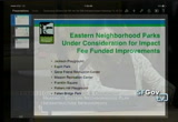
parks and recreation. i have a brief presentation today on the eastern plan for the open space. some of this was covered earlier by the city planning presentation. i think there is one fundamental commitment made as part of eastern neighborhoods. we would create four new open spaces and we are very well poised to follow through on that commitment. as noted in the earlier presentation 17 and folsom is a good example of the collaboration that's gone on between the planning and the parks and recreation and the community , we are able to use those impact fees to secure that site and complete a design. that project is on hold now to make time for the puc to create storm water catch basin underneath the park. once that
2:49 pm

is complete, we should be able to move forward. i think that spirit of collaboration is what we want to continue to repeat and all the other projects that we are considering for the eastern neighborhoods. we have at this point two very successful meetings with the eastern neighborhoods with cac around outlining a process about how we can work together to identify capital improvements that would be funding through the eastern neighborhoods and impact fees and using the matching funds and geo bonds and other sources. what we have discuss with the cac and planning department is what should the major renovation projects be that we undertake. we feel we have a strong acquisition stronl at this point between planning recreation and parks. we have not done much with the
2:50 pm

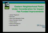
series renovation projects to serve the additional population that we are expecting. looking at the portfolio projects that parks and recreation opens and maintains in the eastern neighborhood. we came up with a list of priority projects based on feedback from the community and also our own understanding of the general condition of those cites and the extent to which they are also have been unable to generate funds for those projects and there are parks that need to be renovated and parks that we've been able to renovate with the trusted land and other partners and there is others that we have not been able to find other funding for providing. some of those parks include jackson playground, mission rec's,
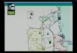
2:51 pm
franklin square, and potrero hill, which is the name of the property but it's the rec's center that seems to be an outstanding place, the cal trans property maintains and the city wants us to integrate that sight further and make potential improvements. here is a map of the eastern neighborhoods and where these sites are located. i think our main goal is to try to develop a policy framework for how we want to identify the sites that we are vetting. our main goal is to develop a focus list of projects that we would require the impact fees to again the design of those projects and develop really a mini capital
2:52 pm
plan around the use of eastern neighborhoods for impact fees for open space. we met with the neighborhood cic in spep -- september where they reviewed the funds for the project and the bonds and the cac enthusiastically agreed to allocate additional funds on that project. we'll be able to start construction on that project in fall of next year. besides 17th and folsom, that feels like a great promise we are focusing on. and we talked to cac to talk about what these projects would look like and we agreed on the following steps which is we are going to try to come back in march to the cac with menu of options and what
2:53 pm
the scope would look like and the associated budget and looking at that as well as the projected cash flow for the eastern neighborhood we want to come up with a comprehensive plan for how to move forward. as i said the process so far has been marked by a high degree of cooperation and we are very excited about the opportunities we have here to potentially make some long requested improvements in the community. with that i'm happy to answer any additional questions? >> okay. there is no questions here. thank you for your presentation. >> actually i have a couple quick questions. how did you come to select the priorities? >> the first was around the condition of those properties. we are focusing on properties
2:54 pm
that have not received a significant amount of capital to date. these are properties that have not received a lot of attention. secondly, i think the ability, we try and think of our capital program looking at all the funding sources together. so again, looking at the funding source that from the geo bonds and other partnerships, these are the properties that didn't have a plan in place for them where the needs have been identified but we hadn't identified a clear funding source and third is utilization and just a sense from within the recreation and parks department of how these facilities are being used and whether not they play a core role in the community. >> is there a plan continually support and maintain these open spaces? >> i think that the plan is to continue to use our existing
2:55 pm
general fund resources to support the maintenance of these spaces as they are maintained now. we acknowledge there is more maintenance resources for all of our properties. but i think with existing general fund resources we have, our propc scores over the past years demonstrate that we continue to actually with limited resources don't improve our efforts and second we find a lot of the maintenance associated with these sites is because they are aging out and in such poor conditions. we are able to reduce the existing maintenance burden associated with it. >> thank you very much. next we'll hear from john thomas from dpw. >> good morning. john thomas public manager with boks
2:56 pm
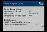
department of public works. i have a few slides to highlight the levels of work we have under way by the department. focusing on the work demonstrated areas while coordinating with other city departments. these include sidewalk inspection, street resurfacing, curb ramp construction throughout the city and all of those while trying to implement the strategy and the better streets plan. in 2011 the road and
2:57 pm
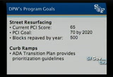
pavement bond. the condition at that time was at 64 and we plan to make it 72 citywide and we have maintained streets at the good condition level. we have in the past year improved from 64-65. that effort that the bond addressed was to provide 3 years of increased funding over our standard levels from 2004-2011. we have jump started that process. it's an overall 10-year plan to bring us to that pci score of 70. we are in year two of the bond implementation. the next slide illustrates those projects. i gave you a handout that might be a little bit easier to read.
2:58 pm
what you will see on that slide are all of our completed streets and resurfacing in green. the blocks that are planned over the next few years are in red and similarly we show the street and intersection for curb ramps and planned intersection in green and in red if they are planned in the next couple of years. in addition to that we highlight on that map several of the streetscape projects through eastern neighborhoods. those projects include potrero avenue streetscape which is worked being done in cord nation with the mta to assist in the implementation of the dwp recommendation and potrero project for streetscape is about $2 million in investment
2:59 pm
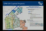
and we are repairing all of portrero division to 25th for approximately $3 million and infrastructure improvement from puc. the second project is approximately $14 million in the environmental stage at this point. caesar chavez is about a $10 million project and in the final stages of construction. we have a couple hours in the eastern neighborhoods streetscape. bart is in the design phase at this point. and 24th street had some minor streetscape improvement for pedestrian lighting and sidewalk replacement which was completed this past fall. that concludes my overview of
3:00 pm
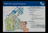
the projects that we have in the eastern neighborhoods. i would be happy to answer any questions you might have. >> i have a question. are these maps different? >> it's the same map but i cut it to make it larger on the powerpoint. >> that's perfect, thank you. supervisor campos, did you have a question? >> a quick probably dumb question and maybe it's not possible to do it. i wonder if there is a way to have a map thatten incorporates the various projects in the eastern neighborhood. in other words something that maybe it's not fobl -- possible to do that but to incorporate what everybody is thinking to have something that come
52 Views
IN COLLECTIONS
SFGTV: San Francisco Government Television Television Archive
  Television Archive News Search Service
Uploaded by TV Archive on
